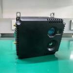
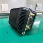
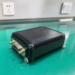
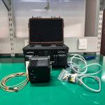
This is a highly integrated UAV navigation system designed to provide autonomous and reliable positioning and attitude information for UAVs in environments where Global Navigation Satellite System (GNSS) signals are completely or partially unavailable. The system integrates multiple independent information acquisition channels, possessing extremely high fault tolerance and accuracy.
Core Technology Foundation: The system is based on a multimodal information fusion architecture, combining artificial intelligence algorithms to adaptively filter and fuse data from various sensors. The core concept is to leverage the complementary advantages of different sensors to compensate for the deficiencies of a single sensor.
Main Channels and Components:
Laser Channel (LiDAR/Radar): Utilizes laser pulses to construct a high-precision 3D environmental map and measure target distances, providing high-precision relative position information.
Infrared Channel (Thermal Imager): Supports operation in low-light, dark, and strong optical interference environments, using thermal contrast to identify landmarks and correct heading.
Inertial Measurement Unit (IMU): Provides high-frequency angular velocity and acceleration measurements, compensating for short-term signal loss from other sensors and ensuring smooth trajectory estimation.
Satellite Correction Module: When signal availability is available, it periodically corrects long-term drift using GNSS (GPS, GLONASS, BeiDou) signals and automatically switches to other channels in interference environments.
Machine Vision Module: Processes visible light images and determines absolute position by matching them with a map, supporting autonomous positioning in GPS-free environments.
Working Principle: The system continuously collects data from all sensors. The central computing unit uses deep learning algorithms (such as visual odometry and SLAM) to build environmental maps in real time and calculate the UAV's pose. When the quality of a signal source deteriorates (e.g., GNSS loses lock in an urban canyon), the system automatically adjusts weights using AI algorithms, switching to laser, infrared, or visual navigation to ensure continuous and high-precision navigation in complex environments.
Applicable Scenarios: Complex environment mapping, high-voltage transmission line and bridge inspection, search and rescue, critical infrastructure security.

 recommended